Burstall Pass

We finally got some snow after several weeks of drought-like conditions. However, this being the rockies, the avalanche hazard was increased as a result. Reports were that the Burstall Pass area was still in pretty good condition, so we decided to check it out.

Getting ready for the hike in. I really need to clean my license plate.
It was a cold day (at least, I thought it was ... more on that later), but once we got into the sun at Burstall Lakes, things felt much better. We even had a bit of blue skies poking out amidst the clouds.

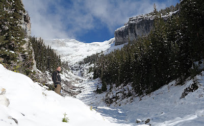
Looking up towards Robertson Glacier.
Once we got above treeline, signs of snow instability were everywhere. We saw a fair bit of cracking, a broken cornice, and some slab avalanches off in the distance. As a result, we did not go all the way up to the top of the pass, and took some more moderate slopes on the way back down, which did Angie no favours. The ski-out gully was in pretty good shape, which was a welcome change from a couple of weeks back.

Eventually, we made it back to the car as the sun was setting, then dropped by the Grizzly Paw for some drinks and burgers before heading back home.

I proceeded to sleep for 15 hours and woke up the next day with flu symptoms. I am guessing that was why I was so tired and cold (among other things).

Watridge Lake

We had an easy day skiing to and around Watridge Lake, catering to Carol's still-healing arm and Scott's lack of any skiing experience.

The ski to Watridge Lake itself went very quickly, owing to Scott's quick grasp of the basics of the kick-and-glide. His technique going down hills needs some work, but for someone who's never really been on skis before, everything else came very quickly.

Watridge Lake trail, with Mount Shark in the background
The ski around Watridge Lake was a bit of an adventure. We skirted the edge of the lake when we felt it was safe, but in a few spots, water was showing, so we made detours into the woods. There was no trail per se, so we had to do some bushwhacking and a few stream crossings. It was the first time I had gotten my skis muddy!

A successful circumnavigation of Watridge Lake
On the way back to the parking lot, we did a small loop diverging from the main trail that ended with a couple of downhill sections.

Too much powder to pick up any speed
I was hoping to get a wipeout, but Scott disappointed
The most aggressive of the lot

Burstall Pass

The ski season started with a bang in early November with a large dump of snow. However, since then, we've had a bit of a drought, and Kananaskis Country hadn't seen any appreciable snow in almost 2 weeks. Conditions were thin everywhere, but we were desperate, so we went to the place most likely to have some powder - Burstall Pass.

Busy day at Burstall parking lot.
Apparently, we were not alone in our thinking. The parking lot was quite packed by the time we got there. We saw the usual assortment of snowshoers and skiers, and we even saw a couple of ice fishermen.

Skiing over Burstall Lakes, with Whistling Rock Ridge in the background.
Even though there wasn't much snow in the lower sections of the trail, the weather was beautiful with perfectly blue skies and an interesting temperature inversion which made the higher elevations warmer than the parking lot.

On top of Burstall Pass, with Snow Peak in the background to the right. Note the exposed rocks.
There were many exposed rocks on top of the pass, but the section between the pass and the gully was pretty good. There were some spots with super hard wind loaded slab, but overall the snow was quite soft, as Ray can attest to. The ski-out gully was quite questionable, but seemed like the safer option over skiing back down the trail up, as there were many exposed roots and rocks in the forest.

All in all, a decent day out with beautiful weather and marginal conditions. Hopefully, it will snow some more!

My journey to 155 and beyond

This entry was written a few months ago. With the lack of updates recently (due to conditions not condusive to getting out to the mountains), I've decided to post it during this lull. I am hoping to do some backcountry skiing soon, so more entries and photos should come.


I've gotten a lot of comments regarding my weight lately, so I thought I'd do a little write-up of what happened.

On November 26th, 2008, I got back home from having spent a month in Nepal, trekking to Everest Base Camp. A couple of weeks later, I have record of having weighed myself at 163 pounds.

A little less than a year later, while celebrating my birthday with Frank and Tiiu, this photo was taken:


If you look carefully (okay, maybe not that carefully ... it's pretty obvious), you can see a bulge on the side of my gut, hanging over my pants, that was large enough to cast a shadow. It was then that I decided I needed to be a bit more serious about my weight, not just to avoid these sorts of photos in the future, but also to improve my performance in the various hobbies that I enjoy.

So, for the first time in my life, I made what I feel to be a real concerted effort to lose weight. I experimented with many things, some of which worked, some of which didn't, but I did learn a lot about my body and physiology.

One thing I learned very quickly is that each person has their own challenges to overcome when it comes to weight. What works for one person will not necessarily work for another, partly because each person has different bad habits that they need to overcome. The following are the things I learned about myself:

0. Weight loss is not rocket science. (calories in) < (calories out) is the simplest way to think of it. My biggest problem was that I thought I could increase (calories out) enough to lose weight, but what I found was that no matter how much I work out, I can ALWAYS eat more. This was probably the most important realization for me.


1. My main problem food is starch (which contains a significant number of calories). More specifically, rice and pasta. I can eat these two things indefinitely without feeling full, and therein lied my first challenge: to control my consumption of starches. Now, there was no way I could cut them out entirely (this is another thing I learned ... you need to make compromises with your body, otherwise your body will win), but I have managed to reduce their intake, especially in the evenings.

2. Big breakfasts. I now force myself to eat a big breakfast, whether I am hungry or not. After a while, my body adapted and I now get hungry in the mornings (previously, I never had more than a coffee for the first couple of hours of being awake). The main reason this has been important to me is that I find I run out of energy very quickly on my morning runs if I don't eat a large breakfast. If I can't run, then I can't burn calories.

3. Managing my cravings. When I feel like sweets, I have some diet ginger ale. When I feel like salt, I have some pickles. Both have negligeable calories.

4. Keep a record of my progress. The following is a graph of my daily weight:

The line in blue is the actual weight measurements, and the curve in red is the running 7 day average. Perhaps I am results driven, but I like seeing that number go down.

Note that the big dip at the end is because I got sick from food poisoning. I would never recommend that as a way to achieve weight loss, but I have been able to maintain my lower weight without any bad side effects.

5. Don't eat things out of convenience. Fortunately, the list of things I crave which are really bad for me is quite small. However, it is still easy to fall into the trap of eating these bad things because they are typically convenient. e.g. potato chips, instant noodles. Either have healthier options handy or commit to the effort needed to prepare healthier options.

6. Snacks. I think different people differ on what role snacks play in their diets. I realize that an ideal diet involves eating small amounts often. However, I found that this does not work for me, as I have difficulty controlling how much I consume. Sure, having 6 small meals is better than having 3 big meals. But in my case, those 6 small meals would turn into 6 big meals, and that wasn't helping anyone. I have largely eliminated snacks out of my diet altogether, and this has helped me to limit my consumption.

7. Know which battles you can't win. I will allow myself to eat pretty much all the ice cream I can stand. It's just one of those battles that I wasn't going to win, so I focused my energies on battles that were winnable instead. e.g. I generally avoid pastries and baked goods. These were not big deals for me, as I never get cravings for them, but I would eat them if they were available. Now, I don't.

These days, I'm hovering in the 150 to 155 range, which I am quite happy with. My climbing and running have improved drastically, and I'm hoping that ski season shows the same sort of results. I often find myself looking forward to my next meal or going to bed hungry, but the results have been worth it.

Mount Ware

Five days of snow!

The forecast in Canmore / Kanasaskis / Banff calls for snow every day for the next five days. This is good news if you're as anxious to start backcountry skiing as I am. However, with the impending snow, hiking season is coming to a close.

Mount Ware is in the southern part of Kananaskis Country, skirting along the edge of Bluerock Wildland Provincial Park. I had never even heard of this park before today, so obviously there's a lot more to Kananaskis Country than what I am familiar with. Access is via Turner Valley along a very innocuous little side road that eventually bursts out into acres and acres of farmland. I'm always amazed at what is hidden in the foothills south of Calgary.

The first half of the trail is shared with horses, so is a bit chopped up and muddy in sections. Eventually, one breaks off the trail and goes cross country through a forest and then some hilly meadows. There was a fair bit of snow cover, even on the trail, but fortunately a couple had passed through earlier (I eventually caught up with them) and they did most of the hard work of figuring out exactly where to go. There are trail markers along the way (little orange and pink ribbons tied to the trees), but sometimes it's just easier to put your head down and trudge uphill.

The last bit to summit Mount Ware is a bit scrambly and loose, although it's probably not all that much worse with the snow than without. The view from the top is quite nice, as you get a very good panoramic view of Bluerock Mountain. The winds were howling in from the west, portending a wet weather system moving in.

Cairn on the summit of Mount Ware (2150m), with Bluerock Mountain (2790m) in the background
And now, it's time to clean the gaiters and boots. My road bike is already clean and in storage, so summer is really at an end. But my skis are waxed and ready to go, so here's to hoping for a good winter.

Forgetmenot Mountain

The snow has been falling on the interior mountains, but the front range is still very much free of the white stuff. As is always the case around this time of year, there isn't enough snow to go skiing, but it is too cold to climb. Those desperate to get out are limited to the front range, and so that's what I did on this day.

Forgetmenot Mountain (and ridge) are accessed via Elbow Falls Trail, which is an area of Kananaskis Country I seldom visit. I'm not sure why that is, but it's quite close to Calgary (less than 1 hour to the trail head from my home) and the scenery, while not as rugged and impressive as the interior, is still quite pleasant.

About half way up to the summit of the ridge, you get a good view of the surrounding mountains. In the centre is Nihahi Ridge, and then moving left, we have Mount Glasgow (the tallest looking one, at 2935m), Mount Cornwall (2978m), Banded Peak (the closer one, 2934m), and Outlaw Peak (2970m).
The hike is quite gradual, although the rocks you have to walk across are a bit awkward (they're the perfect size for rolling your ankles). Getting up to the summit of Forgetmenot Ridge (2330m) took a little under 3 hours. From there, the summit of Forgetmenot Mountain is another hour.

Cairn on the summit of Forgetmenot Ridge
The hike up to the summit of Forgetmenot Mountain is a bit more awkward as there are more blocks of limestone to contend with. However, it's still a hike (as opposed to a scramble)

You can see Calgary from the summit of Forgetmenot Mountain, which means one should be able to point out the summit of Forgetmenot Mountain from Calgary ...
While on the summit of Forgetmenot Mountain, it started to snow, so I figured it was time to go.

This is the valley south of Forgetmenot Mountain, which looks very promising for touring. However, access is via snowmobile (the roads are closed in the winter)
I've always liked the look of a light dusting of snow on a steep face
By the time I got back to the car (6.5 hours), the snow had stopped and the skies were partly blue. I suspect this area will be hikeable next weekend as well, so perhaps I will be back.

Mount Bourgeau

Mount Bourgeau was another of those hikes which I had not been able to complete previously. I had tried in July but turned back for a variety of reasons, one of them being that the summit was completely encased in clouds that day.

The forecast for today was cold (high of 5C) but clear, so I figured this might be my last chance until next year.

"Harvey" is such an ordinary name ... I can never remember it
The hike to the summit of Mount Bourgeau is 12km (one way) with 1350m of elevation gain and a couple of scrambly bits, although those bits are quite small and manageable. Most of the trail up to Bourgeau Lake is in the forest, and the grade is very gentle (I ran down).

First hiker of the day gets to ruin the fresh snow
As I was first to start (another group arrived in the parking lot as I was about to leave), I broke trail in the upper portions beyond Lake Bourgeau, where the snow covered the trail. Fortunately, it's pretty obvious where to go.

Mount Brett (2938m)
Harvey Lake and Mount Assiniboine
As the Copeland book says, Bourgeau Lake is the least of the interesting destinations along this path. I didn't even take a photo of it.

A bit further on, from Harvey Pass, one can see Mount Assiniboine. And from the summit of Mount Bourgeau, you can see ... well, it almost feels as though you can see EVERYTHING.

Mount Bourgeau (the summit is on the rounded dome of scree)
How many mountains can you recognize?
In the above panorama, you can see all of the following:

1. Mount Assiniboine
2. Sunshine ski resort
3. Mount Temple
4. Monarch Ramparts and Healy Pass
5. Summits from the Bugaboos (although I couldn't point them out)

These are all places I had been to before, or plan to go to, so there is a lot of meaning behind the scenery.

Cosmic Ray Road, leading up the backside of Sulfur Mountain
My mother and I had tried to hike up Sulfur Mountain via Cosmic Ray Road one year, but turned back due to it being very cold. It's not the most exciting hike, but it's doable in the shoulder season.

Not what you'd usually expect at the summit of a mountain
The weather station at the summit of Mount Bourgeau is a bit extravagant. It's actually large enough to accomodate a person inside, and there's a lot of instruments as well. I was thankful for it as it gave me shelter from the unrelenting wind. Plus, the weathervanes (I call them "wind roosters") let me know when the wind changed direction and I needed to sit on a different side of the weather station.

Skaha

Ray and I had originally planned to go to Skaha in May, but at the time, the forecast was quite poor so I bailed and we decided to try again in the fall.

We had decided to give Thanksgiving a try, but as the date came up, the forecast was very poor again. At this point, though, I didn't care, and I wanted to get out of Calgary regardless. It was a good thing, as we got 1.5 good days of climbing and a day visiting wineries in the Okanagan region during our rain day.

When we got to the campsite late Friday night (around 12:30am), the wind was howling off of Lake Skaha and setting up camp was quite awkward and difficult. The next morning, I saw lots of fallen branches and debris.

Ray on Mysterious Semblance (Elusive Edge area)
Saturday's plan was to do Logan's Run, but as the routes in that area are a bit stiff for warming up, we stopped by the Elusive Edge area first. I did Climbing with Elvis (5.10a sport) and Golden Pie Crust Award (5.10a sport).

Nicolas on Logan's Run (Great White area)
We all did Logan's Run (5.10b), and as Ethan was coming down after cleaning the route, it started sprinkling so we decided to call it a day.

Ray's ever helpful advice to inexperienced climbers ("go up")
That night, the winds picked up again, and I'm pretty sure I saw one tent tip over.

Campfire overlooking Skaha Lake
The next day, the rains started in the morning and did not give the impression of letting up, so we decided to have a winery day. We visited 4 wineries and I brought back a bunch of fruit wines and dry reds.

Ray on Ready To Strike (Diamondback area)
Our last day was to be a half day, but the weather was beautiful so the hike in was definitely worthwhile. My goal was to do Ready To Strike (5.10a trad), and it was a fantastic experience. I was definitely scared in a couple of places, and I sat on gear (which I never do), but I plan on going back and doing it clean.

Nicolas watching Ray
With my nerves frazzled, I called it a day and Nicolas and I drove back to Calgary.

West Wind Pass

The plan was to do Read's Tower and Mount Sparrowhawk. However, as is often the case, I was up late the night before, and I don't remember turning off my alarm at 5am. Hence, a shorter day was in the cards.

We decided to go up to West Wind Pass, which is in the same general vicinity, but is a much shorter hike.

Paraglider coming off the summit of Windtower
Unfortunately, I wasn't really prepared to do West Wind Pass, and as a result we missed a turnoff and ended up going along the scramble to Rimwall Summit. However, we stayed low enough on the shoulder such that the hike back down to West Wind Pass was quite simple.

What does this sign even mean?
True to its name, West Wind Pass was very windy. However, the wind was going south-to-north, so I'm not sure where "west" comes into play.

Heading back down along the correct trail
On the way back down, we followed the proper hiking trail and it was really easy. I'm glad I did the scramble as it was a bit more interesting, but Akemi would probably disagree.

Middle Sister

On the way out of the city, I saw the aftermath of this:

http://calgary.ctv.ca/servlet/an/local/CTVNews/20100926/CGY_fatal_rollover_100926/20100926/?hub=CalgaryHome

When I drove by, I could see pieces of the car strewn all over the highway, and what looked to be a body covered by a tarp lying on the road. While it saddens me that it appears as though a seat belt might have helped prevent the death, I am glad that this car did not collide with any other cars and cause even more deaths.


Akemi and I had attempted Middle Sister a few years ago, but were turned back by ice along Stewart Creek. This was in the springtime, so I was hoping I would fare better in the fall. The recent weather would surely help the situation.

Sunrise over the Middle Sister trailhead
I got to the trail head about 15 minutes prior to sunrise, and the colours were spectacular.

The trail is fairly easy until you get to the cirque below Big Sister, and even then it's not bad as a good trail has been carved out of the scree slopes. In a few spots, the scree was quite sparse, revealing a smooth slab which would be problematic if icy.

Finally purchased a fully detached home in Canmore (it's a fixer upper)
The views from the summit (2769m) are quite impressive, and makes everything along the south side of the Canmore corridor appear quite small. I was looking down on Three Sisters Pass and Ha Ling.

Spots of larches in Canmore
Unfortunately, Big Sister remained clouded over the entire time I was on the summit, so I eventually gave up and started heading back down.

From left to right - Middle Sister, Little Sister, Grotto Mountain, Wind Ridge (this is a 94 image panorama which took about 10 minutes to shoot)
Of course, by the time I was half way down, the sun came out to taunt me.

Baby Goat
On the way back down Stewart Creek, I almost ran into a momma goat and her baby. I carefully walked past, then took a few shots from about 50 feet away.

Momma Goat

Mount Lipsett

Highway 40 between Kananaskis Lakes Trail and Highwood Junction is still open to vehicular traffic (even though it's been snowing regularly near the Highwood Pass and I went skiing the weekend before), so now is a good time to check out the hikes along that stretch of road.

Parking lot / trail head for both Mount Lipsett and Mist Mountain
I'd never even heard of Mount Lipsett before, and didn't realize that it was in the Copeland book, but Laureen suggested it and I'm always up for new places.

The hike itself is very easy as it does a very (VERY) gradual switchback up the east side of Mount Lipsett. Once you get out of the trees, the scenery is of rolling hills and brief spots of rocky outcrops.

Summit of Mount Lipsett, with Mist Mountain towering above in the background
The terrain here looks very inviting for skiing. Too bad the trail head is 25km from either highway closure.

Or maybe this is the summit of Mount Lipsett
One has the option of bushwhacking back down to the highway from here, but we took the trail back to the parking lot.

HDR practice for Roger
For Roger: this was my first pass at creating an HDR image using the 3 raw files I supplied to you. If I were to spend more time on it, I'd probably try to increase the contrast of the foreground a bit more.

Mount Rundle

Mike was coming to a conference in Banff, and this gave me an excuse to take a vacation day mid-week and spend it in the mountains. I was a little concerned by the amount of snow I saw on the summit the past weekend while mountain biking along Goat Creek, but as I had never been on the true summit of Mount Rundle before (I'd done the south summit, which is accessed from Whiteman's Gap), decided it was worth a try.

Alan Kane says not to go up this gully
The first section through the forest is quite dull and tedious, but once the trees started thinning out, we had a fair bit of snow to negotiate.

As we left the treeline, things started getting tricky as some sections were slabs with some loose rock and lots of slush. These did not inspire confidence as we went up the Dragon's Back, and we saw another party heading back down due to the conditions.

Trying not to slide down the slab-and-slush
We eventually made it to the narrowest section of the Dragon's Back, but it was here that we stopped, as there was a good 100 feet of dropoff on either side, and the conditions were very condusive to sliding. So, we enjoyed the view, then headed back down.

The summit of Mount Assiniboine, peaking out through the clouds
The view from where we were, which was probably around 500m from the top, was spectacular. Apparently, Mount Temple is visible as well, but I'm not sure what it looks like from this side, so I wasn't able to isolate it in a shot.

Sulfur Mountain, with the Sundance Range behind it
Moonrise over Pigeon Mountain
As I was driving back home, I saw a full moon rising over Pigeon Mountain, so I did the tourist thing and took a shot from the shoulder of the highway.