Back in 2008, a friend of ours organized a large group trip to Glacier National Park for day hiking based out of the A.O. Wheeler hut. As Glacier National Park is about 3.5 hours from our home in Calgary, it was not an area we had visited much (other than driving through to get to other places like Skaha and Squamish). However, during the trip, our eyes were opened to the fantastic hikes in the area, and we vowed to come back and spend some more time there.
Fast forward to 2010, and we are finally keeping our promise to ourselves.
We decided to stay at the Wheeler hut again as it was very comfortable and cozy, and with my newfound appreciation for huts and shelters in general, things worked out really well.
August 11, 2010
 |
| Dinner on the first night |
We decided to simply drive out on the first day and not do any hikes. This gave us the opportunity to take a very leisurely pace, and we spent some time shopping in Banff along the way.
Staying at the hut also allowed us to pack in some things we normally would not have on a backcountry trip, like two days' worth of fresh food. We even brought a cooler, which we thought might be overkill until we saw the stacks upon stacks of styrofoam coolers in the hut already; as there was a large group from ACC Ottawa spending 2 weeks at the hut.
 |
| Whole wheet pasta with ground pork and tomato sauce |
This was also to be my first trip with my new camera body (Nikon D700), so I was looking forward to seeing what it could do in the field.
 |
| Ruins |
Nearby are the ruins of the old Glacier House, a hotel that was popular during the time when folks would travel through the mountains via train. There is an interpretive walk that one can do to read up on the history of the area.
 |
| Unknown flower |
 |
| Main dining area of the Wheeler hut |
In addition to the group from Ottawa, there was also a large group from Germany, guided by a local guide company, who arrived later in the day. Even though the hut was quite crowded, everyone was friendly and things went smoothly in the kitchen.
 |
Front of the Wheeler hut, which is actually the alternate entrance
|
August 12, 2010
Our hike for the first day was a combination of Mount Sir Donald basecamp and Perley Rock, as they both share a 3.2 km section.
 |
| A brook on the way to Mount Sir Donald / Perley Rock |
Mount Sir Donald (which you will see in later photos, as it was covered in clouds the day we were at basecamp) is a very popular climbing destination in the area, as the peak is very aesthetic and apparently fairly easy (the most popular route, the northwest ridge, is 5.4), although long. The basecamp is situated at the base, next to a glacier-fed stream, and we had lunch there.
Perley Rock is not really a mountain per se. From far away, it actually looks like a bump in the side of the ridge that leads down from Mount Sir Donald. However, when standing next to it, it's not a bad place for a view of the Illecillewaet Glacier. Unfortunately, the clouds were rolling in and as I was taking this picture, I heard what I thought was an avalanche or rockslide, but it turned out to be thunder.
 |
| Illecillewaet Glacier |
 |
| Akemi waiting patiently |
We got absolutely soaked on the way back down to the hut, and the warm fire which was waiting for us was very welcome.
August 13, 2010
 |
| Lots of butterflies led the way along the trail |
The forecast had originally called for rain on this day and the next day, but the thunderstorm from the previous day cleared everything up and we had beautiful blue skies for the rest of the trip.
 |
| Ridge on the way up to the Asulkan Hut |
The hike for the day was into the Asulkan Valley, which would eventually lead to the Asulkan hut. The hike, especially the ridge pictured above, was fantastic. One thing about hikes in the Roger's Pass area is that they all require a sizeable price of admission (steep), but the rewards are always worth it.
 |
| Panorama from a hill overlooking the Asulkan Hut |
The Asulkan hut is very popular in the winter, as the bowl just behind it is fantastic for skiing. We will have to consider coming up sometime. The hut itself has all the amenities you would expect from an ACC hut, and it even has a gas fireplace!
 |
| Back at home |
Back at the hut, it was now quiet as both the Ottawa group and the German group had left. It was just the two of us and one other guy, who was climbing Mount Sir Donald the next day.
August 14, 2010
 |
| A tree cannon, hallowed out by pine beetles perhaps? |
The hike for today was Avalanche Crest. The guidebook calls this a strenuous hike, but I didn't feel as though it was any more difficult than anything we had done up to that point. In fact, the 0.8 km up to Mount Sir Donald from the intersection felt like the longest 800 metres ever.
 |
| Wildflowers galore |
In hindsight, I think this was the least impressive hike we did on the trip, partly because at the top of Avalanche Crest, you could see Highway 1. However, we did not proceed all the way to the summit as it required some scrambling and we felt as though we had gotten our money's worth already.
 |
| Relaxing near the top of Avalanche Crest |
 |
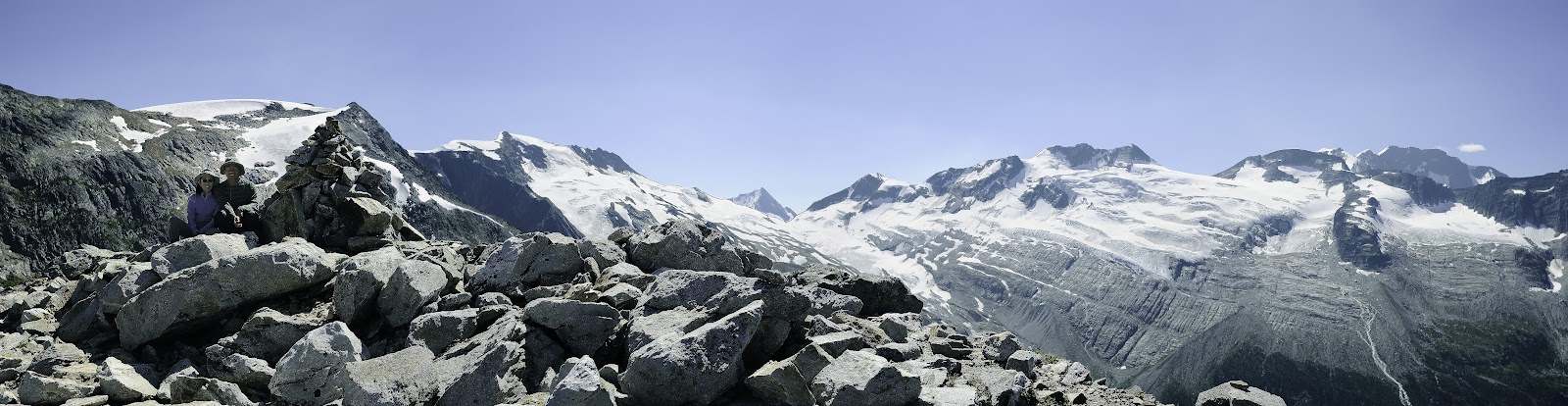
| Panorama from the top of Avalanche Crest |
That night, we were the only people at the hut, and Akemi swears she heard footsteps outside behind the rear entrance (pictured earlier), but whoever it was did not try to enter the hut (which was locked from that side).
August 15, 2010
The order of the hikes ended up being quite serendipitous, as the hike for the day, Glacier Crest, allowed us to see, from a bird's eye view, many of the hikes we had done previously.
 |
| Abbot Ridge, which we had done two years ago |
 |
| Asulkan hut, which we had done two days ago |
The summit of Glacier Crest had fantastic views of the entire area. As this was to be our last full day in the area, we lingered at the summit for a while, enjoying the views and chatting with another couple that had gotten there just minutes prior.
 |
| Akemi and I on the summit of Glacier Crest, with the Asulkan glacier in the background |
 |
| Akemi taking a nap |
As we rested at the summit, Akemi noticed a pika busily building his / her nest. I sat with her for a good 15 minutes before he popped his head out again.
 |
| Pika |
 |
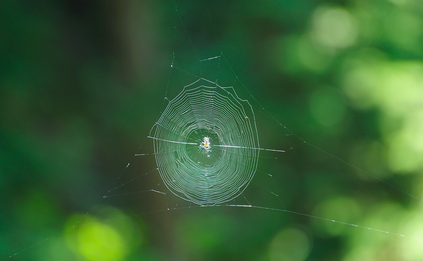
| A smart spider builds her web where passing hikers would not break through |
August 16, 2010
Our last day! The only non-trivial hike out of the Wheeler hut that we did not do was Great Glacier, so we'll have to come back some day and see what it's like. Instead, we decided to do Balu Pass, which came highly recommended. It starts at the back of the Parks Canada information centre, and had a reputation for bears, and we were not disappointed!
 |
| Not sure what would cause this ... maybe avalanches? |
The hike follows a drainage up to Balu Pass, and either side is thick with trees. At one point, I could hear many squirrels chirping away, and I figured it was a warning that a human was passing by, but in hindsight, I guess they know that bears are more dangerous.
This guy looked like an adolescent grizzly, about 200 feet from where this shot was taken. He would run away a bit, turn around and take a look, then run some more, then take another look. His curiousity was competing with his instinct to hide, but in the end, he was a good bear and disappeared into the trees, but not before I got a few shots of him.
 |
| Hello Mister Bear |
 |
| Top of Balu Pass |
The pass itself is quite nice, and there is what appears to be an alpine outhouse hidden in the trees. However, the trail leading to it was blocked off due to the presence of bears (no kidding!), so we did not investigate. We did spend some time enjoying the cool breeze blowing through as it was a brutally hot day (easily 30C).
 |
| Looking back on the valley leading up to Balu Pass |
 |
| Panorama from the base of the switchbacks leading up to the top of Balu Pass |
And we were done! Our big cravings were a cold beer and fish and chips, and as luck would have it, we found a place that had both! What a coincidence.
For those of you who like short, steep hikes with fantastic mountain panoramas, Roger's Pass is the place for you. Next time, we hope to do the Great Glacier trail as well as perhaps Bostock Creek and the Bald Hills backpacking loop. Until next time!