There are some exposed, avalanche-prone slopes on Mount Field, but the weather and avalanche conditions were such that we decided to at least get to treeline to see how things looked up top.
Yoho Valley Road was boring and tedious, as usual. It seems like Parks Canada doesn't trackset the road anymore, although they have in the past. No trailbreaking was required as the area had seen lots of activity, although we were the first to arrive on this day.
Once past the switchback, we headed into the trees before the first bridge, following a clear set of uptracks. Through the forest we went, always looking up at the scary cornices hanging off of Wapta Mountain.
 |
| Finally out of the trees |
Beyond the last of the trees, we stopped to discuss the snow quality and overhead dangers on several occasions. The terrain was quite scary and didn't let up much, varying from about 20 degrees to 40 degrees. Just below the final steep headwall, we almost turned back, but the snow quality made us feel as though it was safe to proceed.
We got to the col between the summit and a subpeak, and from here we could see the town of Field. This section was scary as a slide would result in going over the steep cliff on the south side. Even though we were confident that the snow was stable, it took a lot of mental strength to keep our legs moving.
 |
| On the summit, looking west, past what I think is a buried cairn |
 |
| Emerald Peak and the big slide path that was the scene of a size 4.0 avalanche a couple of years ago |
 |
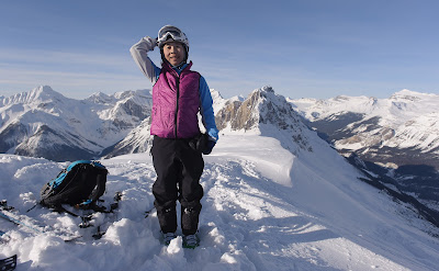
| Brave enough to stand at the summit! |
 |
| I felt much more comfortable sitting |
 |
| Looking back at our line |
Alas, the fun ended there, as the ski back to the car was tedious and painful. But that's the price you pay!
Oh, and Chic Scott's claim that this trip is 16km round trip? I don't think so. My GPS said 23.30km, as the link below will show.
http://www.endomondo.com/workouts/158267168/3101909
No comments:
Post a Comment